
Carte topographique Surigao City
Carte interactive
Cliquez sur la carte pour afficher l’altitude.
Surigao City
Surigao City is marked by rolling hills that gently buffers its eastern and western boundaries. To the south-west towers the Kabangkaan Ridge which divides the city from the municipality of San Francisco (formerly Anao-aon). Kinabutan River (otherwise known as Surigao River) meanders Surigao valley before it empties to the Surigao tidal basin, a shrinking mangrove swamp fast overtaken by the city's expansion. It has an average elevation of 19 meters or 65.5 ft. above sea level. The highest elevation on the mainland at the Kabangkaan Ridge has a peak elevation of 465 meters above sea level. Along the border of Tagana-an is Mapawa Peak with an elevation of 245 meters above sea level. Barangays Cabongbongan, Nabago and Capalayan are at the foot of its slopes.
À propos de cette carte
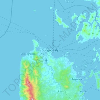
Nom : Carte topographique Surigao City, altitude, relief.
Lieu : Surigao City, Surigao del Norte, Caraga, 8400, Philippines (9.63055 125.33334 9.95055 125.65334)
Altitude moyenne : 40 m
Altitude minimum : -1 m
Altitude maximum : 953 m
Autres cartes topographiques
Cliquez sur une carte pour visualiser sa topographie, son altitude et son relief.