
Carte topographique Beaulieu
Carte interactive
Cliquez sur la carte pour afficher l’altitude.
À propos de cette carte
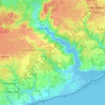
Nom : Carte topographique Beaulieu, altitude, relief.
Altitude moyenne : 19 m
Altitude minimum : -5 m
Altitude maximum : 46 m
Autres cartes topographiques
Cliquez sur une carte pour visualiser sa topographie, son altitude et son relief.
Brook
Vereinigtes Königreich > England > Hampshire > New Forest > Bramshaw
Brook, Bramshaw, New Forest, Hampshire, England, SO43 7HE, Vereinigtes Königreich
Altitude moyenne : 65 m
St Leonards
Vereinigtes Königreich > England > Hampshire > New Forest
St Leonards, Beaulieu, New Forest, Hampshire, England, SO42 7XG, Vereinigtes Königreich
Altitude moyenne : 8 m
Exbury
Vereinigtes Königreich > England > Hampshire > New Forest
Exbury, Exbury and Lepe, New Forest, Hampshire, England, SO45 1AH, Vereinigtes Königreich
Altitude moyenne : 14 m
Brockenhurst
Vereinigtes Königreich > England > Hampshire > New Forest
Brockenhurst, New Forest, Hampshire, England, Vereinigtes Königreich
Altitude moyenne : 39 m
East End
Vereinigtes Königreich > England > Hampshire > New Forest
East End, New Forest, Hampshire, England, SO41 5SY, Vereinigtes Königreich
Altitude moyenne : 12 m