
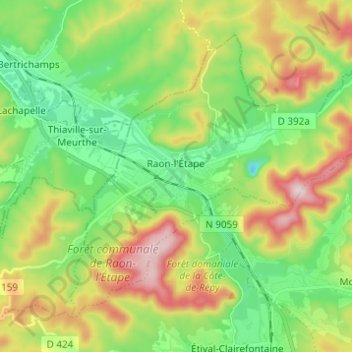
Carte topographique Raon-l'Étape
Carte interactive
Cliquez sur la carte pour afficher l’altitude.
À propos de cette carte
Nom : Carte topographique Raon-l'Étape, altitude, relief.
Altitude moyenne : 362 m
Altitude minimum : 219 m
Altitude maximum : 604 m
Raon-l'Étape is positioned at the mouth of the Plaine [fr] at the point where it converges into the Meurthe, itself a tributary of the Moselle. Because it is on departmental frontier with the adjacent Meurthe-et-Moselle département, Raon-l'Étape is sometimes known as the "Gateway to the Vosges" (porte des Vosges). The town is positioned at a point where relatively flat lands transform into a much more mountainous topography: the mountains have for centuries restricted the options for travellers between francophone France and Alsace (formerly the western reaches of the Empire on the other side of the Vosges). The position of Raon has therefore been critical to influencing the movements of merchandise in peace time and of armies in war time for many centuries.
Autres cartes topographiques
Cliquez sur une carte pour visualiser sa topographie, son altitude et son relief.
Dogneville
Dogneville, Épinal, Vosges, Grand Est, Metropolitan France, 88000, France
Altitude moyenne : 337 m
Les Plombes
France > Grand Est > Vosges > Xonrupt-Longemer
Les Plombes, Xonrupt-Longemer, Saint-Dié-des-Vosges, Vosges, Grand Est, Metropolitan France, 88400, France
Altitude moyenne : 882 m
Les Sources
France > Grand Est > Vosges > Bussang
Les Sources, Bussang, Épinal, Vosges, Grand Est, Metropolitan France, 88540, France
Altitude moyenne : 806 m
Ramberchamp
France > Grand Est > Vosges > Gérardmer
Ramberchamp, Gérardmer, Saint-Dié-des-Vosges, Vosges, Grand Est, Metropolitan France, 88400, France
Altitude moyenne : 786 m
La Petite-Fosse
La Petite-Fosse, Saint-Dié-des-Vosges, Vosges, Grand Est, Metropolitan France, 88490, France
Altitude moyenne : 565 m
Maxey-sur-Meuse
Maxey-sur-Meuse, Neufchâteau, Vosges, Grand Est, Metropolitan France, 88630, France
Altitude moyenne : 325 m
La Vôge-les-Bains
France > Grand Est > Vosges > La Vôge-les-Bains
La Vôge-les-Bains, Épinal, Vosges, Grand Est, Metropolitan France, 88240, France
Altitude moyenne : 379 m
Bellefontaine
Bellefontaine, Épinal, Vosges, Grand Est, Metropolitan France, 88370, France
Altitude moyenne : 544 m
Neufchâteau
Neufchâteau, Vosges, Grand Est, Metropolitan France, 88300, France
Altitude moyenne : 334 m
La Croix-aux-Mines
La Croix-aux-Mines, Saint-Dié-des-Vosges, Vosges, Grand Est, Metropolitan France, 88520, France
Altitude moyenne : 705 m
Ménil-sur-Belvitte
Ménil-sur-Belvitte, Épinal, Vosges, Grand Est, Metropolitan France, 88700, France
Altitude moyenne : 315 m