
Carte topographique Ben Cat Town
Carte interactive
Cliquez sur la carte pour afficher l’altitude.
À propos de cette carte
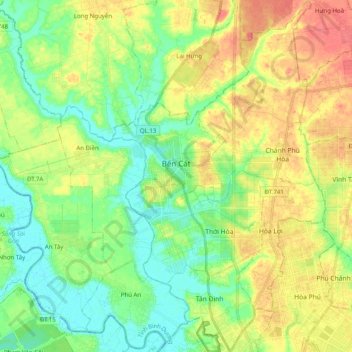
Nom : Carte topographique Ben Cat Town, altitude, relief.
Lieu : Ben Cat Town, Bình Dương Province, 75900, Vietnam (11.03422 106.50770 11.22963 106.69419)
Altitude moyenne : 25 m
Altitude minimum : -5 m
Altitude maximum : 61 m
Ben Cat is in the transition zone from the Trường Sơn range in the north of the central highland to the southern plain, so the general topography of the whole town is relatively high from 30 to 35m above sea level in the north and lower to the south. In the south, the climate belongs to the tropical savanna region, there is little flooding and the average annual rainfall is about 1,500-2,500mm, the average monthly temperature is 32°C during the day and 23°C at night, the hottest month is 36 °C and the coldest month is 16°C. In mid-December, the town often has dense fog in the early morning and ends at 7-8am.
Autres cartes topographiques
Cliquez sur une carte pour visualiser sa topographie, son altitude et son relief.
Phường Chánh Phú Hòa
Vietnam > Binh Duong Province > Ben Cat Town
Phường Chánh Phú Hòa, Ben Cat Town, Bình Dương Province, Vietnam
Altitude moyenne : 36 m
Saigon River
Saigon River, Binh Duong province, 71107, Vietnam
Altitude moyenne : 42 m
Lái Thiêu
Vietnam > Binh Duong Province > Thuan An City
Lái Thiêu, Thuan An City, Binh Duong province, 000084, Vietnam
Altitude moyenne : 9 m
Di An
Vietnam > Binh Duong Province > Di An City > Di An
Di An, Di An City, Binh Duong province, 824791, Vietnam
Altitude moyenne : 12 m
Binh Duong New City
Vietnam > Binh Duong Province > Binh Duong New City
Binh Duong New City, Thu Dau Mot City, Binh Duong province, Vietnam
Altitude moyenne : 32 m