
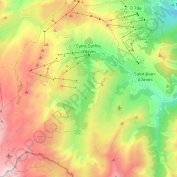
Carte topographique Saint-Sorlin-d'Arves
Carte interactive
Cliquez sur la carte pour afficher l’altitude.
À propos de cette carte
Nom : Carte topographique Saint-Sorlin-d'Arves, altitude, relief.
Altitude moyenne : 1 998 m
Altitude minimum : 1 033 m
Altitude maximum : 3 210 m
It is a ski resort, part of the larger Les Sybelles area. Gaston Maulin's project of linking St Sorlin with the La Toussuire and Le Corbier ski resorts has created Les Sybelles, an area that ranks high in the list of the largest French ski areas, with over 300 kilometres of intermediate level skiing. The St Sorlin area has over 120 kilometres of pistes and is generally considered to have the best runs and be the best placed sector of the Sybelles area. With village slopes starting at 1550 metres and a current maximum lift altitude of 2620 metres there is normally good snow until the end of April but there are also plenty of strategically placed snow cannons. St Sorlin has a 16 km cross country ski trails, 4 green, 11 blue, 9 red and 2 black runs with beginners slopes in the village.
Autres cartes topographiques
Cliquez sur une carte pour visualiser sa topographie, son altitude et son relief.
Les Déserts
France > Auvergne-Rhône-Alpes > Savoy
Les Déserts, Chambéry, Savoy, Auvergne-Rhône-Alpes, Metropolitan France, 73230, France
Altitude moyenne : 1 247 m
Les Contamines
France > Auvergne-Rhône-Alpes > Savoy > Albiez-Montrond
Les Contamines, Albiez-Montrond, Saint-Jean-de-Maurienne, Savoy, Auvergne-Rhône-Alpes, Metropolitan France, 73300, France
Altitude moyenne : 1 382 m
Aussois
France > Auvergne-Rhône-Alpes > Savoy > Aussois
Aussois, Saint-Jean-de-Maurienne, Savoy, Auvergne-Rhône-Alpes, Metropolitan France, 73500, France
Altitude moyenne : 2 055 m
Attignat-Oncin
France > Auvergne-Rhône-Alpes > Savoy
Attignat-Oncin, Chambéry, Savoy, Auvergne-Rhône-Alpes, Metropolitan France, 73610, France
Altitude moyenne : 625 m
Chambéry
France > Auvergne-Rhône-Alpes > Savoy > Chambéry
Chambéry, Savoy, Auvergne-Rhône-Alpes, Metropolitan France, 73000, France
Altitude moyenne : 376 m
Tignes
France > Auvergne-Rhône-Alpes > Savoy
Tignes, Albertville, Savoy, Auvergne-Rhône-Alpes, Metropolitan France, 73320, France
Altitude moyenne : 2 520 m