
Carte topographique Posthudorra/Porto Torres
Carte interactive
Cliquez sur la carte pour afficher l’altitude.
À propos de cette carte
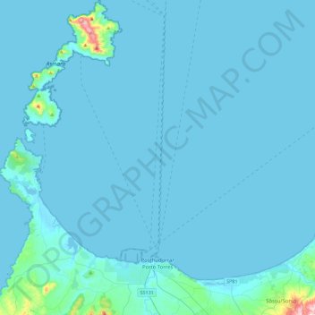
Nom : Carte topographique Posthudorra/Porto Torres, altitude, relief.
Lieu : Posthudorra/Porto Torres, Sassari, Sardinia, 07046, Italy (40.78142 8.20876 41.12073 8.45885)
Altitude moyenne : 15 m
Altitude minimum : -1 m
Altitude maximum : 418 m
The morphology of "city part" is flat; the area of Porto Torres and the rest of north-west Sardinia is characterized by a Nurra plain, with some hill formations in the middle of it. Part of this hill formation is in the municipality of Porto Torres, the highest elevation being Monte Alvaro, rising to a height of 342 m above sea level.
Autres cartes topographiques
Cliquez sur une carte pour visualiser sa topographie, son altitude et son relief.
Li Scalitti
Italy > Sardinia > Sassari > Badesi
Li Scalitti, Badesi, Sassari, Sardinia, 07030, Italy
Altitude moyenne : 71 m
Putumajore/Pozzomaggiore
Putumajore/Pozzomaggiore, Sassari, Sardinia, 07018, Italy
Altitude moyenne : 411 m
Sòssu/Sorso
Sòssu/Sorso, Sassari, Sardinia, 07037, Italy
Altitude moyenne : 107 m