
Carte topographique Chaco
Carte interactive
Cliquez sur la carte pour afficher l’altitude.
À propos de cette carte
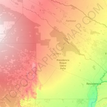
Nom : Carte topographique Chaco, altitude, relief.
Lieu : Chaco, Argentina (-28.08360 -63.42230 -24.07925 -58.37756)
Altitude moyenne : 124 m
Altitude minimum : 37 m
Altitude maximum : 282 m
Autres cartes topographiques
Cliquez sur une carte pour visualiser sa topographie, son altitude et son relief.
Municipio de General José de San Martín
Municipio de General José de San Martín, Departamento Libertador General San Martín, Chaco, Argentina
Altitude moyenne : 73 m
Departamento Libertad
Departamento Libertad, Chaco, Argentina
Altitude moyenne : 58 m
Resistencia
Argentina > Chaco > Resistencia
Resistencia, Departamento San Fernando, Chaco, Argentina
Altitude moyenne : 51 m
Aramburu
Argentina > Chaco > Resistencia
Aramburu, Resistencia, Departamento San Fernando, Chaco, Argentina
Altitude moyenne : 53 m