
Carte topographique Enniscorthy
Carte interactive
Cliquez sur la carte pour afficher l’altitude.
À propos de cette carte
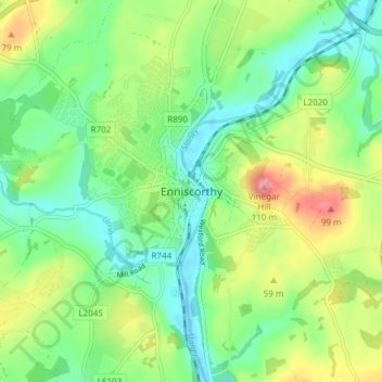
Nom : Carte topographique Enniscorthy, altitude, relief.
Altitude moyenne : 38 m
Altitude minimum : -1 m
Altitude maximum : 107 m
Autres cartes topographiques
Cliquez sur une carte pour visualiser sa topographie, son altitude et son relief.
Glynn
Glynn, The Borough District of Wexford, Comté de Wexford, Leinster, Y35 CY80, Irlande
Altitude moyenne : 41 m
Shelburne
Shelburne, Comté de Wexford, Leinster, Irlande
Altitude moyenne : 31 m
Bruce
Bruce, Ballygarrett ED, The Municipal District of Gorey — Kilmuckridge, Comté de Wexford, Leinster, Irlande
Altitude moyenne : 37 m
Lucas's Park
Lucas's Park, Enniscorthy Rural ED, The Municipal District of Enniscorthy, Comté de Wexford, Leinster, Irlande
Altitude moyenne : 31 m