Géolocaliser

Carte topographique Farmersburg

Carte interactive

Cliquez sur la carte pour afficher l’altitude.

À propos de cette carte

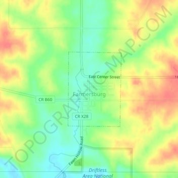
Nom : Carte topographique Farmersburg, altitude, relief.

Lieu : Farmersburg, Clayton County, Iowa, United States (42.95350 -91.37225 42.96481 -91.36120)

Altitude moyenne : 297 m

Altitude minimum : 267 m

Altitude maximum : 328 m

Autres cartes topographiques

Cliquez sur une carte pour visualiser sa topographie, son altitude et son relief.

Garber

United States > Iowa > Clayton County

Garber, Clayton County, Iowa, United States

Altitude moyenne : 231 m

Strawberry Point

United States > Iowa > Clayton County

Strawberry Point, Clayton County, Iowa, United States

Altitude moyenne : 354 m

Volga

United States > Iowa > Clayton County

Volga, Clayton County, Iowa, United States

Altitude moyenne : 255 m

Marquette

United States > Iowa > Clayton County

Marquette, Clayton County, Iowa, 52158, United States

Altitude moyenne : 231 m

Garnavillo

United States > Iowa > Clayton County

Garnavillo, Clayton County, Iowa, United States

Altitude moyenne : 315 m

Guttenberg

United States > Iowa > Clayton County

Guttenberg, Clayton County, Iowa, United States

Altitude moyenne : 218 m

Luana

United States > Iowa > Clayton County

Luana, Clayton County, Iowa, 52156, United States

Altitude moyenne : 335 m

North Buena Vista

United States > Iowa > Clayton County

North Buena Vista, Clayton County, Iowa, 52066, United States

Altitude moyenne : 235 m

Osterdock

United States > Iowa > Clayton County

Osterdock, Clayton County, Iowa, United States

Altitude moyenne : 227 m

Clayton

United States > Iowa > Clayton County

Clayton, Clayton County, Iowa, United States

Altitude moyenne : 243 m

Elkport

United States > Iowa > Clayton County

Elkport, Clayton County, Iowa, United States

Altitude moyenne : 226 m

Elkader

United States > Iowa > Clayton County

Elkader, Clayton County, Iowa, United States

Altitude moyenne : 252 m

Pikes Peak State Park

United States > Iowa > Clayton County > McGregor

Pikes Peak State Park, McGregor, Clayton County, Iowa, United States

Altitude moyenne : 250 m

West Yards

United States > Iowa > Clayton County > Marquette > West Yards

West Yards, Marquette, Clayton County, Iowa, 52158, United States

Altitude moyenne : 264 m

Edgewood

United States > Iowa > Clayton County

Edgewood, Clayton County, Iowa, United States

Altitude moyenne : 352 m

St. Olaf

United States > Iowa > Clayton County

St. Olaf, Clayton County, Iowa, United States

Altitude moyenne : 282 m

McGregor

United States > Iowa > Clayton County

McGregor, Clayton County, Iowa, United States

Altitude moyenne : 251 m