
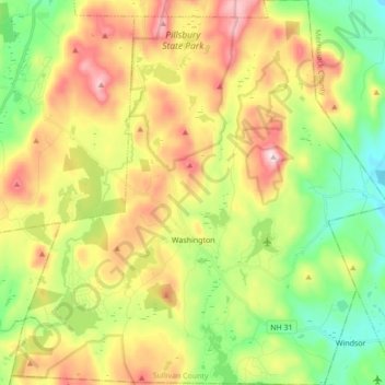
Carte topographique Washington
Carte interactive
Cliquez sur la carte pour afficher l’altitude.
À propos de cette carte
Nom : Carte topographique Washington, altitude, relief.
Altitude moyenne : 466 m
Altitude minimum : 265 m
Altitude maximum : 742 m
Lovewell Mountain, located northeast of the town center and with an elevation of 2,496 feet (761 m), is the highest point in town. As Edwin A. Charlton writes in New Hampshire As It Is (1855), the mountain "received its name from Captain John Lovewell, who was accustomed to ascend it for the purpose of discovering the wigwams of the Indians, and who, on one occasion, killed seven Indians near its summit." The Washington Town Common, elevation 1,507 feet (459 m), is the highest town center in the state. (The town hall of Clarksville in northern New Hampshire is located at a higher elevation—1,980 feet (600 m)—but there is no other village development there.)
Autres cartes topographiques
Cliquez sur une carte pour visualiser sa topographie, son altitude et son relief.
Plainfield
United States > New Hampshire > Sullivan County
Plainfield, Sullivan County, New Hampshire, United States
Altitude moyenne : 267 m
Unity
United States > New Hampshire > Sullivan County
Unity, Sullivan County, New Hampshire, United States
Altitude moyenne : 369 m
Lempster
United States > New Hampshire > Sullivan County
Lempster, Sullivan County, New Hampshire, 03605, United States
Altitude moyenne : 425 m
Springfield
United States > New Hampshire > Sullivan County > Springfield
Springfield, Sullivan County, New Hampshire, United States
Altitude moyenne : 416 m
Charlestown
United States > New Hampshire > Sullivan County
Charlestown, Sullivan County, New Hampshire, 03603, United States
Altitude moyenne : 256 m
Claremont
United States > New Hampshire > Sullivan County
Claremont, Sullivan County, New Hampshire, United States
Altitude moyenne : 236 m