
Faire un don
Équipez-vous pour votre prochaine aventure :
En tant que Partenaire Amazon, ce site perçoit une commission sur les achats éligibles sans surcoût pour vous.
Carte topographique Trig Point
Cliquez sur la carte pour afficher l’altitude.
Faire un don
Équipez-vous pour votre prochaine aventure :
En tant que Partenaire Amazon, ce site perçoit une commission sur les achats éligibles sans surcoût pour vous.
À propos de cette carte
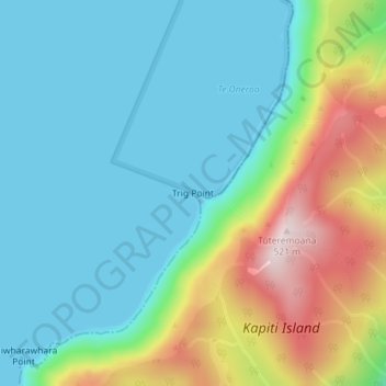
Nom : Carte topographique Trig Point, altitude, relief.
Lieu : Trig Point, Wellington, New Zealand (-40.84567 174.90692 -40.84557 174.90702)
Altitude moyenne : 136 m
Altitude minimum : 0 m
Altitude maximum : 498 m
Faire un don
Équipez-vous pour votre prochaine aventure :
En tant que Partenaire Amazon, ce site perçoit une commission sur les achats éligibles sans surcoût pour vous.
Autres cartes topographiques
Cliquez sur une carte pour visualiser sa topographie, son altitude et son relief.
Faire un don
Équipez-vous pour votre prochaine aventure :
En tant que Partenaire Amazon, ce site perçoit une commission sur les achats éligibles sans surcoût pour vous.
Faire un don
Équipez-vous pour votre prochaine aventure :
En tant que Partenaire Amazon, ce site perçoit une commission sur les achats éligibles sans surcoût pour vous.
Cook Strait
The strait is named after James Cook, the first European commander to sail through it, in 1770. The waters of Cook Strait are dominated by strong tidal flows. The tidal flow through Cook Strait is unusual in that the tidal elevation at the ends of the strait are almost exactly out of phase with one another, so…
Altitude moyenne : 70 m
Tararua Forest Park
The park supports diverse ecosystems, from lowland podocarp-broadleaf forest to alpine tussock tops. Common canopy trees include rimu, rātā, kāmahi and tawa, with beech forest dominating higher elevations. The alpine zone features tussocks, leatherwood and alpine herbs.
Altitude moyenne : 276 m
Faire un don
Équipez-vous pour votre prochaine aventure :
En tant que Partenaire Amazon, ce site perçoit une commission sur les achats éligibles sans surcoût pour vous.
Lake Wairarapa
New Zealand > Wellington > South Wairarapa District > Featherston Community
Altitude moyenne : 106 m
Faire un don
Équipez-vous pour votre prochaine aventure :
En tant que Partenaire Amazon, ce site perçoit une commission sur les achats éligibles sans surcoût pour vous.
Kapiti Island
New Zealand > Wellington > Kapiti Coast District
The full original name for the island is Te Waewae-Kapiti-o-Tara-rāua-ko-Rangitāne, meaning "the boundary of Tara and Rangitāne" and referring to it as a place where the rohe (territories) of Ngāi Tara (now known as Muaūpoko) and Rangitāne (descendents of Whātonga) iwi adjoined each other. The word…
Altitude moyenne : 55 m
Faire un don
Équipez-vous pour votre prochaine aventure :
En tant que Partenaire Amazon, ce site perçoit une commission sur les achats éligibles sans surcoût pour vous.
Faire un don
Équipez-vous pour votre prochaine aventure :
En tant que Partenaire Amazon, ce site perçoit une commission sur les achats éligibles sans surcoût pour vous.
Faire un don
Équipez-vous pour votre prochaine aventure :
En tant que Partenaire Amazon, ce site perçoit une commission sur les achats éligibles sans surcoût pour vous.
Faire un don
Équipez-vous pour votre prochaine aventure :
En tant que Partenaire Amazon, ce site perçoit une commission sur les achats éligibles sans surcoût pour vous.
Hector River
New Zealand > Wellington > South Wairarapa District > Greytown Community
Altitude moyenne : 779 m
Faire un don
Équipez-vous pour votre prochaine aventure :
En tant que Partenaire Amazon, ce site perçoit une commission sur les achats éligibles sans surcoût pour vous.
Faire un don
Équipez-vous pour votre prochaine aventure :
En tant que Partenaire Amazon, ce site perçoit une commission sur les achats éligibles sans surcoût pour vous.
Lake Ōnoke
New Zealand > Wellington > South Wairarapa District > Featherston Community
Altitude moyenne : 2 m
Faire un don
Équipez-vous pour votre prochaine aventure :
En tant que Partenaire Amazon, ce site perçoit une commission sur les achats éligibles sans surcoût pour vous.
Lake Wairarapa
New Zealand > Wellington > South Wairarapa District > Featherston Community
Altitude moyenne : 106 m
Kapiti Island
New Zealand > Wellington > Kapiti Coast District
The full original name for the island, Ko te Waewae-Kapiti-o-Tara-rāua-ko-Rangitāne, meaning "the boundary of Tara and Rangitāne", refers to it as a place where the rohe (territories) of Ngāi Tara (now known as Muaūpoko) and Rangitāne iwi adjoined each other. The word kapiti (to be joined) is spelt…
Altitude moyenne : 55 m