
Carte topographique Aylesbury
Carte interactive
Cliquez sur la carte pour afficher l’altitude.
À propos de cette carte
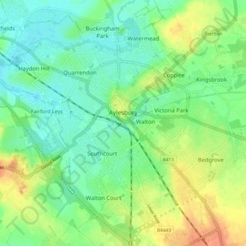
Nom : Carte topographique Aylesbury, altitude, relief.
Lieu : Aylesbury, Buckinghamshire, England, United Kingdom (51.79480 -0.86065 51.83261 -0.77269)
Altitude moyenne : 85 m
Altitude minimum : 70 m
Altitude maximum : 107 m
Aylesbury is immediately southeast of the upper River Thame that flows past Thame to Dorchester on Thames and is partly sited on the two northernmost outcrops of Portland (lime)stone in England bisected by a small stream, Bear Brook which gives a relatively prominent position in relation to the terrain of all near, lower, fields and suburbs, which have largely slowly permeable Oxford Clay and Kimmeridge Clay soils. Elevations range from 72.5m above mean sea level to 95m AOD in contiguous parts of the town, however nearest villages range from 85m-90m to the north or from 85m to 115m on a narrow ridge to the southwest at Stone and towards the Chilterns to the southeast (Weston Turville, Stoke Mandeville and North Lee).
Autres cartes topographiques
Cliquez sur une carte pour visualiser sa topographie, son altitude et son relief.
High Wycombe
United Kingdom > England > Buckinghamshire
High Wycombe, Buckinghamshire, England, United Kingdom
Altitude moyenne : 124 m
West Wycombe
United Kingdom > England > Buckinghamshire > West Wycombe
West Wycombe, Buckinghamshire, England, United Kingdom
Altitude moyenne : 124 m
Chalfont St Giles
United Kingdom > England > Buckinghamshire
Chalfont St Giles, Denham, Gerrards Cross and Chalfonts Community Board, Buckinghamshire, England, United Kingdom
Altitude moyenne : 107 m
Mentmore
United Kingdom > England > Buckinghamshire
Mentmore, Buckinghamshire, England, United Kingdom
Altitude moyenne : 99 m
Akeley
United Kingdom > England > Buckinghamshire
Akeley, Buckinghamshire, England, United Kingdom
Altitude moyenne : 113 m
Amersham
United Kingdom > England > Buckinghamshire > Amersham
Amersham, Buckinghamshire, England, United Kingdom
Altitude moyenne : 137 m