
Carte topographique Encañada
Carte interactive
Cliquez sur la carte pour afficher l’altitude.
À propos de cette carte
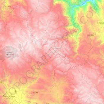
Nom : Carte topographique Encañada, altitude, relief.
Lieu : Encañada, Province of Cajamarca, Cajamarca, Peru (-7.16532 -78.60175 -6.79894 -78.18369)
Altitude moyenne : 3 421 m
Altitude minimum : 1 518 m
Altitude maximum : 4 244 m
One of the highest elevations of the district is the Llusk'a Qullpa mountain range at approximately 4,000 m (13,000 ft) on the border with the Namora District. Other mountains are listed below:
Autres cartes topographiques
Cliquez sur une carte pour visualiser sa topographie, son altitude et son relief.
Province of San Marcos
Province of San Marcos, Cajamarca, 06321, Peru
Altitude moyenne : 2 783 m
Bambamarca
Bambamarca, Province of Hualgayoc, Cajamarca, Peru
Altitude moyenne : 3 247 m
Province of San Pablo
Province of San Pablo, Cajamarca, Peru
Altitude moyenne : 2 959 m
Province of San Marcos
Peru > Cajamarca > José Sabogal
Province of San Marcos, José Sabogal, San Marcos, Cajamarca, Peru
Altitude moyenne : 3 865 m