
Carte topographique Jabung
Cliquez sur la carte pour afficher l’altitude.
À propos de cette carte
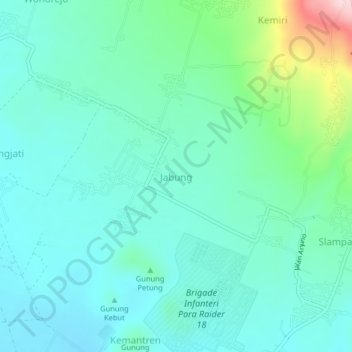
Nom : Carte topographique Jabung, altitude, relief.
Lieu : Jabung, Kabupaten Malang, East Java, Indonesia (-7.94110 112.72089 -7.90110 112.76089)
Altitude moyenne : 573 m
Altitude minimum : 517 m
Altitude maximum : 792 m
Autres cartes topographiques
Cliquez sur une carte pour visualiser sa topographie, son altitude et son relief.
Bromo Tengger Semeru National Park
Indonesia > East Java > Kabupaten Malang
Bromo Tengger Semeru National Park (Indonesian: Taman Nasional Bromo Tengger Semeru; abbreviated as TNBTS) is a national park located in East Java, Indonesia, to the east of Malang and Lumajang, to the south of Pasuruan and Probolinggo, and to the southeast of Surabaya, the capital of East Java. It is the only…
Altitude moyenne : 1 343 m
Dsn. Blau Ds. Permanu Kec. Pakisaji, Malang
Indonesia > East Java > Kabupaten Malang
Altitude moyenne : 478 m