
Carte topographique Ourense
Carte interactive
Cliquez sur la carte pour afficher l’altitude.
À propos de cette carte
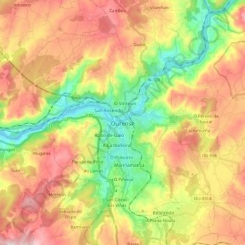
Nom : Carte topographique Ourense, altitude, relief.
Lieu : Ourense, Galicia, Spain (42.28951 -8.00350 42.39830 -7.80595)
Altitude moyenne : 322 m
Altitude minimum : 87 m
Altitude maximum : 581 m
The ancient city of Auria is located on both banks of the Minho (Miño) River in the south-central part of Galicia, at an elevation of 128 m above sea level.