
Carte topographique Middleton ED
Carte interactive
Cliquez sur la carte pour afficher l’altitude.
À propos de cette carte
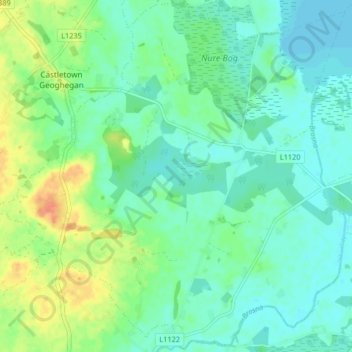
Nom : Carte topographique Middleton ED, altitude, relief.
Altitude moyenne : 89 m
Altitude minimum : 77 m
Altitude maximum : 116 m
Autres cartes topographiques
Cliquez sur une carte pour visualiser sa topographie, son altitude et son relief.
Copperalley ED
Copperalley ED, The Municipal District of Mullingar — Kinnegad, County Westmeath, Condado de Westmeath, Leinster, Irlanda
Altitude moyenne : 78 m
Mullingar
Irlanda > County Westmeath > Mullingar
Mullingar, The Municipal District of Mullingar — Kinnegad, County Westmeath, Leinster, N91 FY58, Irlanda
Altitude moyenne : 101 m