
Carte topographique Colyton
Carte interactive
Cliquez sur la carte pour afficher l’altitude.
À propos de cette carte
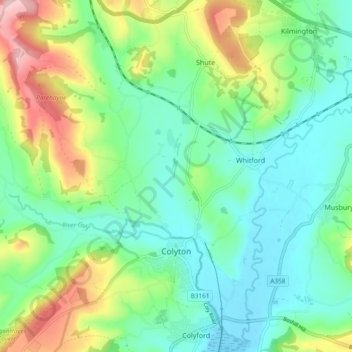
Nom : Carte topographique Colyton, altitude, relief.
Lieu : Colyton, East Devon, Devon, England, United Kingdom (50.72766 -3.14178 50.77899 -3.04752)
Altitude moyenne : 67 m
Altitude minimum : -1 m
Altitude maximum : 225 m
Autres cartes topographiques
Cliquez sur une carte pour visualiser sa topographie, son altitude et son relief.
Exmouth
United Kingdom > England > Devon > East Devon
Exmouth, East Devon, Devon, England, United Kingdom
Altitude moyenne : 29 m
Burrow
United Kingdom > England > Devon > East Devon > Broadclyst > Burrow
Burrow, Broadclyst, East Devon, Devon, England, United Kingdom
Altitude moyenne : 30 m