
Faire un don
Équipez-vous pour votre prochaine aventure :
En tant que Partenaire Amazon, ce site perçoit une commission sur les achats éligibles sans surcoût pour vous.
Carte topographique Beerenberg
Cliquez sur la carte pour afficher l’altitude.
Faire un don
Équipez-vous pour votre prochaine aventure :
En tant que Partenaire Amazon, ce site perçoit une commission sur les achats éligibles sans surcoût pour vous.
À propos de cette carte
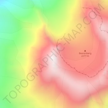
Nom : Carte topographique Beerenberg, altitude, relief.
Lieu : Beerenberg, Jan Mayen, Norway (71.08087 -8.17577 71.08097 -8.17567)
Altitude moyenne : 1 762 m
Altitude minimum : 1 088 m
Altitude maximum : 2 243 m
Faire un don
Équipez-vous pour votre prochaine aventure :
En tant que Partenaire Amazon, ce site perçoit une commission sur les achats éligibles sans surcoût pour vous.
Autres cartes topographiques
Cliquez sur une carte pour visualiser sa topographie, son altitude et son relief.
Jan Mayen
Jan Mayen consists of two geographically distinct parts. Nord-Jan has a round shape and is dominated by the 2,277 m (7,470 ft) high Beerenberg volcano with its large ice cap (114.2 km2 or 44 sq mi), which can be divided into twenty individual outlet glaciers. The largest of those is Sørbreen, with an area of…
Altitude moyenne : 95 m