
Carte topographique Mount Ruapehu
Carte interactive
Cliquez sur la carte pour afficher l’altitude.
Mount Ruapehu
Ruapehu has a polar tundra climate (Köppen: ET) on the upper slopes, with average temperatures ranging from −4–15 °C in summer and −7–7 °C in winter, depending on elevation and cloudiness. On the lower slopes, Ruapehu has a subpolar oceanic climate (Köppen: Cfc).
À propos de cette carte
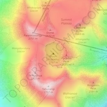
Nom : Carte topographique Mount Ruapehu, altitude, relief.
Altitude moyenne : 2 474 m
Altitude minimum : 2 077 m
Altitude maximum : 2 755 m