
Carte topographique Ambuklao Dam
Carte interactive
Cliquez sur la carte pour afficher l’altitude.
À propos de cette carte
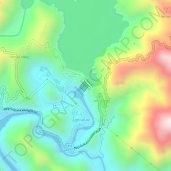
Nom : Carte topographique Ambuklao Dam, altitude, relief.
Altitude moyenne : 808 m
Altitude minimum : 598 m
Altitude maximum : 1 190 m
SNAP-Benguet began a massive rehabilitation project that restored Ambuklao to operating status and increased its capacity from 75 MW to 105 MW. The project required the construction of a new intake, headrace and penstock, elevation of tailrace tunnel outlet, de-silting of tailrace tunnel and replacement of electro-mechanical components. In June 2011, Unit 3 became the first turbine unit to go on-line, followed by the other two units. Ambuklao was formally inaugurated in October 2011.