
Carte topographique Mae Hong Son Province
Carte interactive
Cliquez sur la carte pour afficher l’altitude.
À propos de cette carte
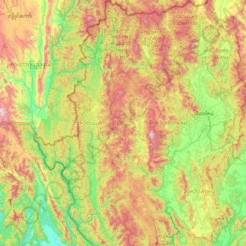
Nom : Carte topographique Mae Hong Son Province, altitude, relief.
Lieu : Mae Hong Son Province, Thailand (17.56653 97.34381 19.81427 98.65251)
Altitude moyenne : 704 m
Altitude minimum : 26 m
Altitude maximum : 2 546 m
The Daen Lao Range, in the northernmost portion of the province, marks the northern boundary between Thailand and Burma, while the Dawna Range in the west serves as the boundary between Thailand and Burma. The Thanon Thongchai Range in the east of the province serves as the boundary between the provinces of Mae Hong Son and Chiang Mai. The highest point of the province is Doi Mae Ya (ยอดเขาแม่ยะ), in the Pai District in the province's northeast, at 2,005 metres (6,578 ft) elevation.
Autres cartes topographiques
Cliquez sur une carte pour visualiser sa topographie, son altitude et son relief.
Surat Thani
Thailand > Surat Thani Province
Surat Thani, Wat Pradu, Surat Thani Province, 84000, Thailand
Altitude moyenne : 10 m
Pa Tong
Thailand > Phuket Province > Kathu > Patong
Pa Tong, Patong, Kathu, Phuket Province, 83150, Thailand
Altitude moyenne : 100 m
Baan Thong Krut
Thailand > Surat Thani Province
Baan Thong Krut, Surat Thani Province, 84010, Thailand
Altitude moyenne : 38 m
Kraburi River
Kraburi River, Ranong Province, Thailand
Altitude moyenne : 50 m
Lampang
Lampang, Ton Thong Chai, Lampang Province, 14001, Thailand
Altitude moyenne : 293 m
Ko Pha Ngan
Thailand > Surat Thani Province
Ko Pha Ngan, Surat Thani Province, Thailand
Altitude moyenne : 84 m
Ban Ton Pho
Thailand > Pathum Thani Province > Suan Phrik Thai Subdistrict Administrative Organization > Suan Phrik Thai Subdistrict
Ban Ton Pho, Suan Phrik Thai Subdistrict, Suan Phrik Thai Subdistrict Administrative Organization, Mueang Pathum Thani District, Pathum Thani Province, 12160, Thailand
Altitude moyenne : 4 m
Maha Sarakham
Thailand > Maha Sarakham Province
Maha Sarakham, Waeng Nang, Maha Sarakham Province, 44000, Thailand
Altitude moyenne : 146 m
Ban Chao Fa
Thailand > Ban Mai Rimthang Mu 6
Ban Chao Fa, Ban Mai Rimthang Mu 6, San Phak Wan, Saraphi District, 50230, Thailand
Altitude moyenne : 311 m
Tapi River
Thailand > Surat Thani Province
Tapi River, Surat Thani Province, Thailand
Altitude moyenne : 123 m
Ban Yai Ka Ta
Thailand > Phra Nakhon Si Ayutthaya Province > Uthai Subdistrict Administrative Organization > Uthai Subdistrict
Ban Yai Ka Ta, Uthai Subdistrict, Uthai Subdistrict Administrative Organization, Uthai District, Phra Nakhon Si Ayutthaya Province, 13210, Thailand
Altitude moyenne : 4 m
Laem Chabang
Laem Chabang, Takhian Tia, Chon Buri Province, 20230, Thailand
Altitude moyenne : 38 m
Ko Kut
Thailand > Trat Province > Ao Ta Nin
Ko Kut, Ao Ta Nin, Trat Province, Thailand
Altitude moyenne : 25 m
Ban Thung Setthi
Thailand > Kamphaeng Phet Province
Ban Thung Setthi, Nong Pling, Kamphaeng Phet Province, 62000, Thailand
Altitude moyenne : 80 m
Phetchabun
Thailand > Phetchabun Province
Phetchabun, Phetchabun Province, 67000, Thailand
Altitude moyenne : 120 m
Saraburi
Saraburi, Takut, Saraburi Province, 18000, Thailand
Altitude moyenne : 22 m
Buri Ram
Buri Ram, Isan, Buri Ram Province, 31009, Thailand
Altitude moyenne : 160 m