Carte topographique Trimley St Martin
Cliquez sur la carte pour afficher l’altitude.
Trimley St Martin
In 1741 the Suffolk Traveller John Kirby (topographer) surveyed the area around Felixstowe and in his note on Trimley he mentioned 'the lane to the pouch', which led to a small meadow east of the two churches, which contained a spring of clear water, generally regarded the source of Kingsfleet. The stream and can still be seen following out from a concrete opening which was constructed when the Civil Engineers covered the greater part of the meadow with what is now known as the Trimley Roundabout (A14 Junction 59). During dredging of the stream to assist the construction of the by-pass a mill-stone was discovered which was identified as being medieval. The path which runs between a smock mill, which was near Mill Lane, and the top of pouch meadow is called CrowsWell Way
À propos de cette carte
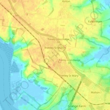
Nom : Carte topographique Trimley St Martin, altitude, relief.
Altitude moyenne : 15 m
Altitude minimum : -6 m
Altitude maximum : 28 m
Autres cartes topographiques
Cliquez sur une carte pour visualiser sa topographie, son altitude et son relief.
Gunton Sands
United Kingdom > England > Suffolk > East Suffolk > Lowestoft > Corton
Altitude moyenne : 10 m


Sutton Hoo Archeological Site
United Kingdom > England > Suffolk > East Suffolk > Sutton
Altitude moyenne : 19 m
Lowestoft Inner Harbour
United Kingdom > England > Suffolk > East Suffolk > Lowestoft > Oulton Broad
Altitude moyenne : 8 m

Site of old Orfordness Lighthouse
United Kingdom > England > Suffolk > East Suffolk > Orford
Altitude moyenne : 0 m


Rendlesham UFO Landing Site #2
United Kingdom > England > Suffolk > East Suffolk > Butley Abbey
Altitude moyenne : 14 m