
Carte topographique Quincy
Cliquez sur la carte pour afficher l’altitude.
Quincy
Quincy has a Mediterranean climate (Köppen Csb) though its inland location and altitude makes it more continental and wetter than usual for this type, with very heavy snowfalls sometimes occurring in winter – the record being 133 inches (337.8 cm) in the very wet January 1916. Although summer days are hot and only 1.4 days per winter fail to top 32 °F (0 °C), nights can be very cold and frosts occur on 179 days per year and have been recorded even in July.
À propos de cette carte
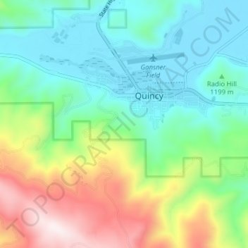
Nom : Carte topographique Quincy, altitude, relief.
Lieu : Quincy, Plumas County, California, United States (39.90682 -120.98896 39.95533 -120.93042)
Altitude moyenne : 1 274 m
Altitude minimum : 1 035 m
Altitude maximum : 1 808 m
Autres cartes topographiques
Cliquez sur une carte pour visualiser sa topographie, son altitude et son relief.
Quincy
United States > California > Plumas County > Quincy
Quincy has a Mediterranean climate (Köppen Csb) though its inland location and altitude makes it more continental and wetter than usual for this type, with very heavy snowfalls sometimes occurring in winter – the record being 133 inches (337.8 cm) in the very wet January 1916. Although summer days are hot…
Altitude moyenne : 1 274 m