
Faire un don
Équipez-vous pour votre prochaine aventure :
En tant que Partenaire Amazon, ce site perçoit une commission sur les achats éligibles sans surcoût pour vous.
Carte topographique Stoner
Cliquez sur la carte pour afficher l’altitude.
Faire un don
Équipez-vous pour votre prochaine aventure :
En tant que Partenaire Amazon, ce site perçoit une commission sur les achats éligibles sans surcoût pour vous.
À propos de cette carte
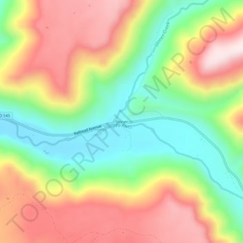
Nom : Carte topographique Stoner, altitude, relief.
Lieu : Stoner, Montezuma County, Colorado, United States (37.56944 -108.34008 37.60944 -108.30008)
Altitude moyenne : 2 494 m
Altitude minimum : 2 257 m
Altitude maximum : 2 757 m
Faire un don
Équipez-vous pour votre prochaine aventure :
En tant que Partenaire Amazon, ce site perçoit une commission sur les achats éligibles sans surcoût pour vous.
Autres cartes topographiques
Cliquez sur une carte pour visualiser sa topographie, son altitude et son relief.
Cortez
United States > Colorado > Montezuma County
Cortez has a dry-summer continental climate (Köppen Dsb), though it borders on a semi-arid climate (BSk) due to low precipitation. The city has hot summer days and cold winter nights, the latter a result of its elevation.
Altitude moyenne : 1 865 m
Mesa Verde National Park
United States > Colorado > Montezuma County
The early Archaic people living near Mesa Verde utilized the atlatl and harvested a wider variety of plants and animals than the Paleo-Indians had while retaining their primarily nomadic lifestyle. They inhabited the outlying areas of the Mesa Verde region, but also the mountains, mesa tops, and canyons, where…
Altitude moyenne : 2 147 m
Mancos
United States > Colorado > Montezuma County
According to the United States Census Bureau, Mancos has a total area of 0.6 square miles (1.6 km2), all of it recorded as land. The town is located in the Mancos River valley at an elevation of approximately 7,000 feet (2,100 m). The Mancos River was named by Spanish explorers (Rio de los Mancos - "River of…
Altitude moyenne : 2 166 m
Faire un don
Équipez-vous pour votre prochaine aventure :
En tant que Partenaire Amazon, ce site perçoit une commission sur les achats éligibles sans surcoût pour vous.
Mancos
United States > Colorado > Montezuma County
According to the United States Census Bureau, Mancos has a total area of 0.6 square miles (1.6 km2), all of it recorded as land. The town is located in the Mancos River valley at an elevation of approximately 7,000 feet (2,100 m). The Mancos River was named by Spanish explorers (Rio de los Mancos - "River of…
Altitude moyenne : 2 158 m
Cortez
United States > Colorado > Montezuma County
Cortez has a dry-summer continental climate (Köppen Dsb), though it borders on a semi-arid climate (BSk) due to low precipitation. The city has hot summer days and cold winter nights, the latter a result of its elevation.
Altitude moyenne : 1 865 m
Faire un don
Équipez-vous pour votre prochaine aventure :
En tant que Partenaire Amazon, ce site perçoit une commission sur les achats éligibles sans surcoût pour vous.
Mancos
United States > Colorado > Montezuma County
According to the United States Census Bureau, Mancos has a total area of 0.6 square miles (1.6 km2), all of it recorded as land. The town is located in the Mancos River valley at an elevation of approximately 7,000 feet (2,100 m). The Mancos River was named by Spanish explorers (Rio de los Mancos - "River of…
Altitude moyenne : 2 166 m
Mesa Verde National Park
United States > Colorado > Montezuma County
The early Archaic people living near Mesa Verde utilized the atlatl and harvested a wider variety of plants and animals than the Paleo-Indians had while retaining their primarily nomadic lifestyle. They inhabited the outlying areas of the Mesa Verde region, but also the mountains, mesa tops, and canyons, where…
Altitude moyenne : 2 147 m
Cortez
United States > Colorado > Montezuma County
Cortez has a dry-summer continental climate (Köppen Dsb), though it borders on a semi-arid climate (BSk) due to low precipitation. The city has hot summer days and cold winter nights, the latter a result of its elevation.
Altitude moyenne : 1 865 m
Faire un don
Équipez-vous pour votre prochaine aventure :
En tant que Partenaire Amazon, ce site perçoit une commission sur les achats éligibles sans surcoût pour vous.