
Carte topographique Lalaye
Carte interactive
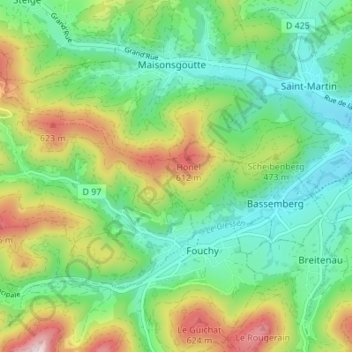
Cliquez sur la carte pour afficher l’altitude.
Lalaye
Lalaye est située à 3 km en amont de la commune de Villé et sur la rive gauche du Giessen d'Urbeis. Elle a une surface de 818 ha. La commune est fermée au nord par l'arête de la Honel qui se maintient autour de 600 mètres d'altitude jusqu'au Blanc-Noyer qui domine la vallée du Giessen de Steige. À l'ouest, les deux ramifications du vallon de Charbes viennent buter sur les puissantes hauteurs du Mont (822 m) qui précèdent le replat où s'est installé le hameau du Climont. Au sud enfin, une ligne de crêtes moins élevé court du Kohlberg (500 m) jusqu'à la Goutte Henri (610 m) et sépare le vallon de la vallée du Giessen proprement dite.
À propos de cette carte
Nom : Carte topographique Lalaye, altitude, relief.
Altitude moyenne : 409 m
Altitude minimum : 266 m
Altitude maximum : 699 m
Autres cartes topographiques
Cliquez sur une carte pour visualiser sa topographie, son altitude et son relief.
Bassin aux Pétroles et Bassin Albert Auberger
France > Grand Est > Bas-Rhin > Strasbourg
Altitude moyenne : 138 m
Col du Pfaffenschlick
France > Grand Est > Bas-Rhin > Climbach > Col du Pfaffenschlick
Le col du Pfaffenschlick se situe dans les Vosges du Nord, dans le département français du Bas-Rhin, au carrefour des RD 51 et 65 entre Climbach et Lobsann d'une part, et Lembach et Schœnenbourg d'autre part. La route franchit le massif du Hochwald et passe à une altitude de 371 mètres.
Altitude moyenne : 353 m
Château du Haut-Kœnigsbourg
France > Grand Est > Bas-Rhin > Orschwiller
Le château est situé dans le massif des Vosges à une altitude de 757 m à 12 km à l'ouest de Sélestat d'où il est visible. Il se trouve également à 26 km au nord de Colmar d'où il est également visible par temps clair et à 55 km au sud de Strasbourg.
Altitude moyenne : 441 m
bassin de rétention des eaux pluviales
France > Grand Est > Bas-Rhin > La Wantzenau
Altitude moyenne : 131 m
Bassin aux Pétroles et Bassin Albert Auberger
France > Grand Est > Bas-Rhin > Strasbourg
Altitude moyenne : 138 m
Mont Sainte-Odile
France > Grand Est > Bas-Rhin > Ottrott
Le mont Sainte-Odile (Odilieberri en alsacien, Odilienberg en allemand) est un mont vosgien, situé à Ottrott dans le département du Bas-Rhin, culminant à 767 mètres d'altitude.
Altitude moyenne : 599 m
Château de l'Oedenbourg ou Petit-Kœnigsbourg
France > Grand Est > Bas-Rhin > Orschwiller
L’Œdenbourg est situé dans le département du Bas-Rhin, sur le territoire de la commune d’Orschwiller. Le château est établi sur une crête rocheuse d’environ 1 000 m de long située à 720 m d’altitude, sur laquelle se trouve également le château du Haut-Koenigsbourg, à environ 250 m à…
Altitude moyenne : 460 m
La Chaume des Veaux
France > Grand Est > Bas-Rhin > Le Hohwald > La Chaume des Veaux
Altitude moyenne : 839 m
Plage de la Ballastière de Bishheim-Schiltigheim
France > Grand Est > Bas-Rhin > Bischheim > Schiltigheim
Altitude moyenne : 135 m