
Carte topographique Valladolid
Carte interactive
Cliquez sur la carte pour afficher l’altitude.
À propos de cette carte
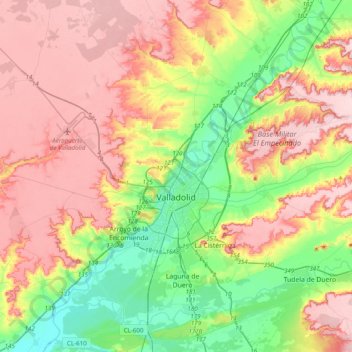
Nom : Carte topographique Valladolid, altitude, relief.
Lieu : Valladolid, Castile and León, Spain (41.52333 -4.92818 41.81551 -4.63087)
Altitude moyenne : 768 m
Altitude minimum : 671 m
Altitude maximum : 868 m
Valladolid is located at roughly 735 metres above sea level, at the centre of the Meseta Norte, the plateau drained by the Duero river basin covering a major part of the Northwest of the Iberian Peninsula. The primitive urban core was built ex novo in the 11th century on a small elevation near the confluence of the Esgueva with the Pisuerga, on the left-bank of the later river. The city of Valladolid currently lies on both banks of the Pisuerga, a major right-bank tributary of the Douro.