Carte topographique Lalla
Carte interactive
Cliquez sur la carte pour afficher l’altitude.
À propos de cette carte
![Carte topographique Lalla, altitude, relief](/pub/maps/relation/fskl/6rz451/thumbnail.jpg)
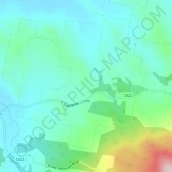
Nom : Carte topographique Lalla, altitude, relief.
Lieu : Lalla, City of Launceston, Tasmanie, 7267, Australie (-41.26968 147.16004 -41.24338 147.20129)
Altitude moyenne : 200 m
Altitude minimum : 105 m
Altitude maximum : 542 m
Autres cartes topographiques
Cliquez sur une carte pour visualiser sa topographie, son altitude et son relief.
![Carte topographique Nile River, altitude, relief](/pub/maps/relation/3214/t5sbzs/icon.jpg)
Nile River
Nile River, Northern Midlands, Tasmanie, Australie
Altitude moyenne : 459 m
![Carte topographique Deal Island, altitude, relief](/pub/maps/relation/h1rr/jt3rs8/icon.jpg)
Deal Island
Deal Island, Flinders Council, Tasmanie, Australie
Altitude moyenne : 45 m
![Carte topographique Mount Mawson, altitude, relief](/pub/maps/node/b3tf/c5dgsptj/icon.jpg)
Mount Mawson
Mount Mawson, Derwent Valley, Tasmanie, Australie
Altitude moyenne : 1 063 m
![Carte topographique Glamorgan-Spring Bay, altitude, relief](/pub/maps/relation/h8mt/lzlzcz/icon.jpg)
Glamorgan-Spring Bay
Glamorgan-Spring Bay, Tasmanie, Australie
Altitude moyenne : 201 m
![Carte topographique Île Macquarie, altitude, relief](/pub/maps/relation/24tj/lw5f9m/icon.jpg)
Île Macquarie
Australie > Tasmanie > Macquarie Island Station
Île Macquarie, Macquarie Island Station, Huon Valley, Tasmanie, Australie
Altitude moyenne : 20 m