
Carte topographique Chuquisaca Department
Carte interactive
Cliquez sur la carte pour afficher l’altitude.
Chuquisaca Department
The department is traversed by the main cordillera of the Andes mountain range and lesser cordilleras. Parts of it lay within the basin of the Amazon River, and other parts within the basin of the Río de La Plata. The surface area of the department is 51,524 square kilometers. The topography of central Chuquisaca consists of a series of ridges rising up to 1500 m that run north and south with flat valleys between the ridges. To the west of these ridges abruptly rise the Andes Mountains to 3000 m forming a prepuna landmass that is cut into by large river valleys that drain into the Amazon or Rio de la Plata river basins. To the east of the central ridges lies a stretch of territory containing low altitude flat Chaco topography. 90% of the land in the department of Chuquisaca has an inclination of 70% or more.
À propos de cette carte
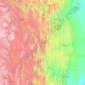
Nom : Carte topographique Chuquisaca Department, altitude, relief.
Lieu : Chuquisaca Department, Bolivia (-21.50840 -65.69568 -18.34880 -62.19332)
Altitude moyenne : 2 054 m
Altitude minimum : 295 m
Altitude maximum : 5 469 m