Géolocaliser

Carte topographique Río Napo

Carte interactive

Cliquez sur la carte pour afficher l’altitude.

À propos de cette carte

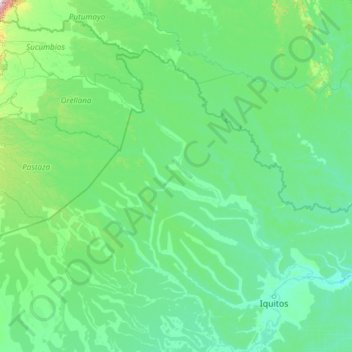
Nom : Carte topographique Río Napo, altitude, relief.

Lieu : Río Napo, Maynas, Loreto, Peru (-3.49320 -77.92577 -0.40902 -72.63503)

Altitude moyenne : 185 m

Altitude minimum : 72 m

Altitude maximum : 3 432 m

Autres cartes topographiques

Cliquez sur une carte pour visualiser sa topographie, son altitude et son relief.

Nazaria

Peru > Loreto > Las Amazonas

Nazaria, Las Amazonas, Maynas, Loreto, Peru

Altitude moyenne : 78 m

Rio Itaya

Peru > Loreto > Belén > Nuevo Campeon

Rio Itaya, Belén, Nuevo Campeon, Belén, Maynas, Loreto, Peru

Altitude moyenne : 90 m

Copacabana

Peru > Loreto > Morona

Copacabana, Morona, Datem del Marañón, Loreto, Peru

Altitude moyenne : 137 m

Santa Rosa de Yavari

Peru > Loreto > Santa Rosa de Yavari

Santa Rosa de Yavari, Mariscal Ramón Castilla, Loreto, Peru

Altitude moyenne : 64 m

Triunfo

Peru > Loreto > Triunfo

Triunfo, Mariscal Ramón Castilla, Loreto, Peru

Altitude moyenne : 76 m

Maynas

Peru > Loreto

Maynas, Loreto, Peru

Altitude moyenne : 140 m

Santander

Peru > Loreto > Pastaza

Santander, Pastaza, Datem del Marañón, Loreto, Peru

Altitude moyenne : 134 m

Puerto Prado

Peru > Loreto > Puerto Prado

Puerto Prado, Ucayali, Loreto, Peru

Altitude moyenne : 148 m

Vitarte

Peru > Loreto > Vitarte

Vitarte, Alto Amazonas, Loreto, Peru

Altitude moyenne : 116 m

Iquitos

Peru > Loreto

Iquitos, Maynas, Loreto, Peru

Altitude moyenne : 94 m

Nuevo Berlin

Peru > Loreto > Nuevo Berlin

Nuevo Berlin, Maynas, Loreto, Peru

Altitude moyenne : 93 m

Maynas

Peru > Loreto > Mazán

Maynas, Mazán, Maynas, Loreto, Peru

Altitude moyenne : 107 m

Huacachina

Peru > Loreto > Huacachina

Huacachina, Loreto, Peru

Altitude moyenne : 107 m