
Faire un don
Équipez-vous pour votre prochaine aventure :
En tant que Partenaire Amazon, ce site perçoit une commission sur les achats éligibles sans surcoût pour vous.
Carte topographique Ålgård
Cliquez sur la carte pour afficher l’altitude.
Faire un don
Équipez-vous pour votre prochaine aventure :
En tant que Partenaire Amazon, ce site perçoit une commission sur les achats éligibles sans surcoût pour vous.
À propos de cette carte
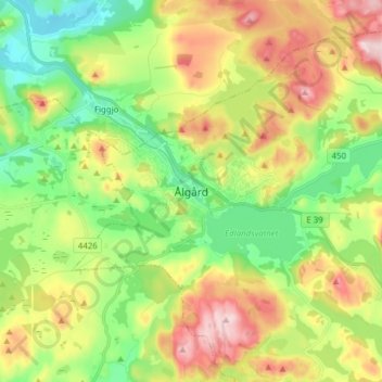
Nom : Carte topographique Ålgård, altitude, relief.
Lieu : Ålgård, Gjesdal, Rogaland, 4330, Norway (58.72921 5.80724 58.80921 5.88724)
Altitude moyenne : 175 m
Altitude minimum : 40 m
Altitude maximum : 378 m
Faire un don
Équipez-vous pour votre prochaine aventure :
En tant que Partenaire Amazon, ce site perçoit une commission sur les achats éligibles sans surcoût pour vous.
Autres cartes topographiques
Cliquez sur une carte pour visualiser sa topographie, son altitude et son relief.
Faire un don
Équipez-vous pour votre prochaine aventure :
En tant que Partenaire Amazon, ce site perçoit une commission sur les achats éligibles sans surcoût pour vous.
Faire un don
Équipez-vous pour votre prochaine aventure :
En tant que Partenaire Amazon, ce site perçoit une commission sur les achats éligibles sans surcoût pour vous.
Faire un don
Équipez-vous pour votre prochaine aventure :
En tant que Partenaire Amazon, ce site perçoit une commission sur les achats éligibles sans surcoût pour vous.
Faire un don
Équipez-vous pour votre prochaine aventure :
En tant que Partenaire Amazon, ce site perçoit une commission sur les achats éligibles sans surcoût pour vous.
Faire un don
Équipez-vous pour votre prochaine aventure :
En tant que Partenaire Amazon, ce site perçoit une commission sur les achats éligibles sans surcoût pour vous.
Stavanger
The municipality of Stavanger is located in a coastal landscape, bordering the sea to the west and Boknafjorden in the northeast. The Byfjorden and Gandsfjorden run along the east side of the city. It is part of the Low-Jæren, a flat area of land consisting mostly of marsh, sand, and stone aur, that ranges…
Altitude moyenne : 42 m
Faire un don
Équipez-vous pour votre prochaine aventure :
En tant que Partenaire Amazon, ce site perçoit une commission sur les achats éligibles sans surcoût pour vous.
Faire un don
Équipez-vous pour votre prochaine aventure :
En tant que Partenaire Amazon, ce site perçoit une commission sur les achats éligibles sans surcoût pour vous.
Stavanger
The municipality of Stavanger is located in a coastal landscape, bordering the sea to the west and Boknafjorden in the northeast. The Byfjorden and Gandsfjorden run along the east side of the city. It is part of the Low-Jæren, a flat area of land consisting mostly of marsh, sand, and stone aur, that ranges…
Altitude moyenne : 37 m
Faire un don
Équipez-vous pour votre prochaine aventure :
En tant que Partenaire Amazon, ce site perçoit une commission sur les achats éligibles sans surcoût pour vous.
Stavanger
The municipality of Stavanger is located in a coastal landscape, bordering the sea to the west and Boknafjorden in the northeast. The Byfjorden and Gandsfjorden run along the east side of the city. It is part of the Low-Jæren, a flat area of land consisting mostly of marsh, sand, and stone aur, that ranges…
Altitude moyenne : 42 m
Faire un don
Équipez-vous pour votre prochaine aventure :
En tant que Partenaire Amazon, ce site perçoit une commission sur les achats éligibles sans surcoût pour vous.