
Carte topographique Ballard County
Carte interactive
Cliquez sur la carte pour afficher l’altitude.
À propos de cette carte
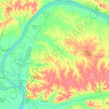
Nom : Carte topographique Ballard County, altitude, relief.
Lieu : Ballard County, Kentucky, USA (36.91546 -89.18251 37.22989 -88.81583)
Altitude moyenne : 113 m
Altitude minimum : 87 m
Altitude maximum : 153 m
Autres cartes topographiques
Cliquez sur une carte pour visualiser sa topographie, son altitude et son relief.
Madisonville
USA > Kentucky > Madisonville
Madisonville, Hopkins County, Kentucky, 42431, USA
Altitude moyenne : 136 m
Bowling Green
USA > Kentucky > Bowling Green
Bowling Green, Warren County, Kentucky, 42101, USA
Altitude moyenne : 169 m
Georgetown
USA > Kentucky > Georgetown
Georgetown, Scott County, Kentucky, 40324, USA
Altitude moyenne : 265 m
Mammoth Cave
USA > Kentucky > Mammoth Cave
Mammoth Cave, Edmonson County, Kentucky, USA
Altitude moyenne : 214 m