
Carte topographique Warlingham
Carte interactive
Cliquez sur la carte pour afficher l’altitude.
À propos de cette carte
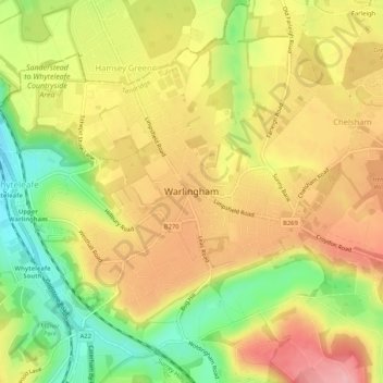
Nom : Carte topographique Warlingham, altitude, relief.
Altitude moyenne : 163 m
Altitude minimum : 90 m
Altitude maximum : 224 m
Elevations vary from 110m AOD at Woldingham Road, at the southernmost point of the parish, with a gentle increase in height through the village along the main road heading to the southeast, to the highest elevation (199.6m) at Limpsfield Road.
Autres cartes topographiques
Cliquez sur une carte pour visualiser sa topographie, son altitude et son relief.
Tandridge District
United Kingdom > England > Surrey > Tandridge District
Tandridge District, Surrey, South East England, England, United Kingdom
Altitude moyenne : 114 m
Nutfield
United Kingdom > England > Surrey > Tandridge District
Nutfield, Tandridge District, Surrey, England, United Kingdom
Altitude moyenne : 88 m
Caterham
United Kingdom > England > Surrey > Tandridge District
Caterham, Tandridge District, Surrey, England, CR3 6XS, United Kingdom
Altitude moyenne : 157 m