
Carte topographique Ax-les-Thermes
Carte interactive
Cliquez sur la carte pour afficher l’altitude.
À propos de cette carte
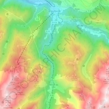
Nom : Carte topographique Ax-les-Thermes, altitude, relief.
Altitude moyenne : 1 449 m
Altitude minimum : 665 m
Altitude maximum : 2 473 m
Ax (from Latin Aquae – water; French Thermes – hot springs), situated at an elevation of 700 metres (2,300 ft), is well known for its sulphurous hot springs (25 to 78 °C or 77 to 172 °F). The waters, which were used by the Romans, were historically claimed to treat rheumatism, skin diseases, and other maladies. The springs were developed in the medieval period on the orders of Saint Louis to treat soldiers returning from the Crusades afflicted with leprosy. From the 19th century, a spa tourism industry developed.
Autres cartes topographiques
Cliquez sur une carte pour visualiser sa topographie, son altitude et son relief.
Rufat
France > Occitania > Ariège > Ax-les-Thermes
Rufat, Ax-les-Thermes, Foix, Ariège, Occitania, Metropolitan France, 09110, France
Altitude moyenne : 994 m