Géolocaliser

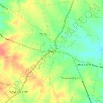
Carte topographique Annur

Cliquez sur la carte pour afficher l’altitude.

Annur

Annur is located at 11°14′N 77°08′E / 11.23°N 77.13°E / 11.23; 77.13.[4] It has an average elevation of 338 metres (1108 feet). Annur is well connected by roads including the National Highway 209 (New NH948) (Coimbatore to Bangalore highway) and the State Highway 80 SH80 Avanashi to Mettupalayam passes through Annur.

Wikipedia (CC-BY-SA 3.0)

À propos de cette carte

Nom : Carte topographique Annur, altitude, relief.

Lieu : Annur, Coimbatore North, Coimbatore District, Tamil Nadu, 638653, India (11.19297 77.06352 11.27297 77.14352)

Altitude moyenne : 381 m

Altitude minimum : 356 m

Altitude maximum : 412 m

Autres cartes topographiques

Cliquez sur une carte pour visualiser sa topographie, son altitude et son relief.

Kembanaikanpalayam

India > Tamil Nadu > Coimbatore North

Altitude moyenne : 393 m

Pannimadai

India > Tamil Nadu > Coimbatore North

Altitude moyenne : 478 m

Ward 34

India > Tamil Nadu > Coimbatore North > Kalapatti

Altitude moyenne : 396 m

Sanganoor Stream

India > Tamil Nadu > Coimbatore North > Coimbatore

Altitude moyenne : 404 m

Pogalur

India > Tamil Nadu > Coimbatore North

Altitude moyenne : 353 m

kalipalayam

India > Tamil Nadu > Coimbatore North

Altitude moyenne : 418 m

Équipez-vous pour votre prochaine aventure :

🛌Matelas de sol isolé - Barrière thermique entre vous et le sol froid
🧴Crèmes solaires outdoor - Protection UV en randonnée
🦟Répulsifs anti-moustiques - Protection contre insectes
🖼️Art mural topographique - Décoration élégante représentant des reliefs célèbres
🧼Savon de camping biodégradable - Respectez l'environnement lors de vos expéditions

En tant que Partenaire Amazon, ce site perçoit une commission sur les achats éligibles sans surcoût pour vous.