
Carte topographique Guangzhou
Carte interactive
Cliquez sur la carte pour afficher l’altitude.
À propos de cette carte
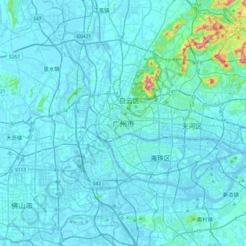
Nom : Carte topographique Guangzhou, altitude, relief.
Lieu : Guangzhou, Guangzhou City, Guangdong Province, 510030, China (22.97020 113.09929 23.29020 113.41929)
Altitude moyenne : 21 m
Altitude minimum : -15 m
Altitude maximum : 364 m
The elevation of the prefecture generally increases from southwest to northeast, with mountains forming the backbone of the city and the ocean comprising the front. Tiantang Peak (天堂顶, "Heavenly Peak") is the highest point of elevation at 1,210 metres (3,970 ft) above sea level.