
Carte topographique Xã Tân An
Carte interactive
Cliquez sur la carte pour afficher l’altitude.
À propos de cette carte
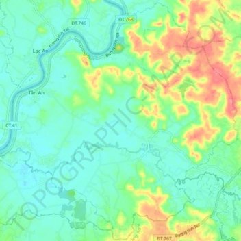
Nom : Carte topographique Xã Tân An, altitude, relief.
Lieu : Xã Tân An, Vĩnh Cửu District, Đồng Nai Province, Vietnam (10.98989 106.90620 11.07559 106.99474)
Altitude moyenne : 23 m
Altitude minimum : 0 m
Altitude maximum : 74 m
Autres cartes topographiques
Cliquez sur une carte pour visualiser sa topographie, son altitude et son relief.
Xã Thiện Tân
Vietnam > Dong Nai province > Vĩnh Cửu District
Xã Thiện Tân, Vĩnh Cửu District, Đồng Nai Province, 76913, Vietnam
Altitude moyenne : 20 m
Xã Mã Đà
Vietnam > Dong Nai province > Vĩnh Cửu District
Xã Mã Đà, Vĩnh Cửu District, Đồng Nai Province, Vietnam
Altitude moyenne : 65 m
Xã Bình Lợi
Vietnam > Dong Nai province > Vĩnh Cửu District
Xã Bình Lợi, Vĩnh Cửu District, Đồng Nai Province, Vietnam
Altitude moyenne : 9 m
Xã Trị An
Vietnam > Dong Nai province > Vĩnh Cửu District
Xã Trị An, Vĩnh Cửu District, Đồng Nai Province, Vietnam
Altitude moyenne : 28 m