
Carte topographique New Delhi
Carte interactive
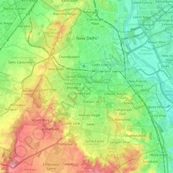
Cliquez sur la carte pour afficher l’altitude.
À propos de cette carte
Nom : Carte topographique New Delhi, altitude, relief.
Lieu : New Delhi, Delhi, India (28.48126 77.05037 28.64568 77.25514)
Altitude moyenne : 230 m
Altitude minimum : 193 m
Altitude maximum : 290 m
With a total area of 42.7 km2 (16.5 sq mi), New Delhi forms a small part of the Delhi metropolitan area. Since the city is located on the Indo-Gangetic Plain, there is little difference in elevation across the city. New Delhi and surrounding areas were once a part of the Aravali Range; all that is left of those mountains is the Delhi Ridge, which is also called the Lungs of Delhi. While New Delhi lies on the floodplains of the Yamuna River, it is essentially a landlocked city. East of the river is the urban area of Shahdara. New Delhi falls under the seismic zone-IV, making it vulnerable to earthquakes.
Autres cartes topographiques
Cliquez sur une carte pour visualiser sa topographie, son altitude et son relief.
Defence Colony Tehsil
Defence Colony Tehsil, South East Delhi District, Delhi, India
Altitude moyenne : 219 m