
Faire un don
Équipez-vous pour votre prochaine aventure :
En tant que Partenaire Amazon, ce site perçoit une commission sur les achats éligibles sans surcoût pour vous.
Carte topographique Bridgewater
Cliquez sur la carte pour afficher l’altitude.
Faire un don
Équipez-vous pour votre prochaine aventure :
En tant que Partenaire Amazon, ce site perçoit une commission sur les achats éligibles sans surcoût pour vous.
Bridgewater
Bridgewater spans the width of the LaHave River Valley and is dominated by hills that lead down to the river. Elevations range from 5 metres above sea level at the river, to nearly 110 m at the southwestern border. Like much of Southern Nova Scotia, the surrounding area is characterized by rolling drumlins formed during the last glacial period, some of which reach 150 metres above sea level. The LaHave River is traversed by two bridges in the centre of the town, as well as a 103 highway overpass and foot bridge towards the northern limits.
Faire un don
Équipez-vous pour votre prochaine aventure :
En tant que Partenaire Amazon, ce site perçoit une commission sur les achats éligibles sans surcoût pour vous.
À propos de cette carte
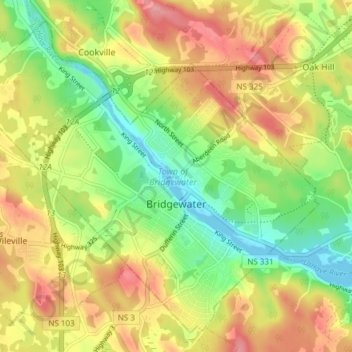
Nom : Carte topographique Bridgewater, altitude, relief.
Lieu : Bridgewater, Lunenburg County, Nova Scotia, Canada (44.35760 -64.56427 44.40550 -64.48875)
Altitude moyenne : 56 m
Altitude minimum : -2 m
Altitude maximum : 118 m
Faire un don
Équipez-vous pour votre prochaine aventure :
En tant que Partenaire Amazon, ce site perçoit une commission sur les achats éligibles sans surcoût pour vous.