
Carte topographique Shantou
Carte interactive
Cliquez sur la carte pour afficher l’altitude.
À propos de cette carte
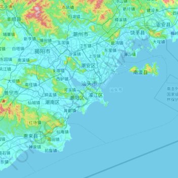
Nom : Carte topographique Shantou, altitude, relief.
Lieu : Shantou, Guangdong, Chine (23.04054 116.23961 23.64342 117.15015)
Altitude moyenne : 40 m
Altitude minimum : -2 m
Altitude maximum : 1 025 m
Autres cartes topographiques
Cliquez sur une carte pour visualiser sa topographie, son altitude et son relief.