
Faire un don
Équipez-vous pour votre prochaine aventure :
En tant que Partenaire Amazon, ce site perçoit une commission sur les achats éligibles sans surcoût pour vous.
Carte topographique Bangkok
Cliquez sur la carte pour afficher l’altitude.
Faire un don
Équipez-vous pour votre prochaine aventure :
En tant que Partenaire Amazon, ce site perçoit une commission sur les achats éligibles sans surcoût pour vous.
Bangkok
Bangkok is in the Chao Phraya River delta in Thailand's central plain. The river meanders through the city in a southerly direction, emptying into the Gulf of Thailand approximately 25 kilometres (16 mi) south of city centre. The area is flat and low-lying, with an average elevation of 1.5 metres (4 ft 11 in) above sea level. Most of the area was originally swampland, which was gradually drained and irrigated for agriculture by the construction of canals (khlong) which took place from the 16th to 19th centuries. The course of the river as it flows through Bangkok has been modified by the construction of several shortcut canals.
Faire un don
Équipez-vous pour votre prochaine aventure :
En tant que Partenaire Amazon, ce site perçoit une commission sur les achats éligibles sans surcoût pour vous.
À propos de cette carte
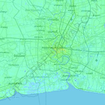
Nom : Carte topographique Bangkok, altitude, relief.
Lieu : Bangkok, Phra Nakhon District, Bangkok, 10200, Thailand (13.49342 100.32788 13.95519 100.93844)
Altitude moyenne : 3 m
Altitude minimum : -12 m
Altitude maximum : 37 m
Faire un don
Équipez-vous pour votre prochaine aventure :
En tant que Partenaire Amazon, ce site perçoit une commission sur les achats éligibles sans surcoût pour vous.
Autres cartes topographiques
Cliquez sur une carte pour visualiser sa topographie, son altitude et son relief.