Géolocaliser

Carte topographique Ramgarh

Carte interactive

Cliquez sur la carte pour afficher l’altitude.

À propos de cette carte

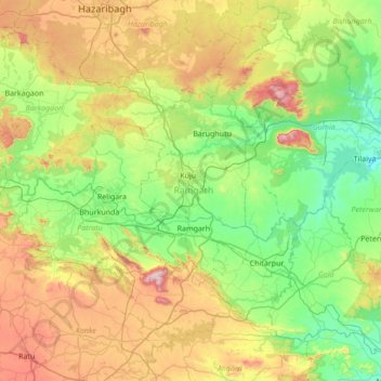
Nom : Carte topographique Ramgarh, altitude, relief.

Lieu : Ramgarh, Jharkhand, Inde (23.41896 85.19757 23.96425 85.88309)

Altitude moyenne : 469 m

Altitude minimum : 217 m

Altitude maximum : 1 023 m

Autres cartes topographiques

Cliquez sur une carte pour visualiser sa topographie, son altitude et son relief.

Kanchi

Inde > Jharkhand > Bundu

Kanchi, Bundu, Ranchi District, Jharkhand, Inde

Altitude moyenne : 453 m

Chāmta

Inde > Jharkhand > Boram

Chāmta, Boram, East Singhbhum District, Jharkhand, Inde

Altitude moyenne : 281 m

Ramgarh

Inde > Jharkhand

Ramgarh, Jharkhand, 825316, Inde

Altitude moyenne : 426 m

Champa

Inde > Jharkhand

Champa, Ranchi, Khunti, Jharkhand, Inde

Altitude moyenne : 451 m

Latehar

Inde > Jharkhand > Latehar

Latehar, Jharkhand, 829206, Inde

Altitude moyenne : 393 m