
Carte topographique Seia
Carte interactive
Cliquez sur la carte pour afficher l’altitude.
À propos de cette carte
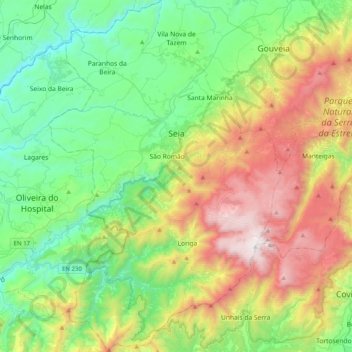
Nom : Carte topographique Seia, altitude, relief.
Lieu : Seia, Guarda, Portugal (40.22992 -7.84923 40.53552 -7.58343)
Altitude moyenne : 754 m
Altitude minimum : 150 m
Altitude maximum : 1 989 m
The municipality is limited to the north by the municipalities of Nelas and Mangualde, to the northeast by Gouveia, to the east by Manteigas, to the southeast by Covilhã, to the southwest by Arganil and to the west by Oliveira do Hospital. In this municipality is located the highest point in mainland Portugal, Torre, in Serra da Estrela, with 1,993 meters of altitude. The municipality of Seia covers a large part of Serra da Estrela and is also the only one in Portugal where there is a natural ski resort, Vodafone Ski Resort, located within the limits of the parish of Loriga.
Autres cartes topographiques
Cliquez sur une carte pour visualiser sa topographie, son altitude et son relief.
Figueira de Castelo Rodrigo
Figueira de Castelo Rodrigo, Guarda, Portugal
Altitude moyenne : 537 m
Aldeia da Serra
Portugal > Guarda > Celorico da Beira
Aldeia da Serra, Celorico (São Pedro e Santa Maria) e Vila Boa do Mondego, Celorico da Beira, Guarda, 6360-393, Portugal
Altitude moyenne : 575 m
Vale de Azares
Portugal > Guarda > Celorico da Beira
Vale de Azares, Celorico da Beira, Guarda, 6360-180, Portugal
Altitude moyenne : 587 m
Site of Community Importance Serra da Estrela
Site of Community Importance Serra da Estrela, Guarda, Portugal
Altitude moyenne : 742 m
Cântaro Magro
Cântaro Magro, Manteigas, Guarda, Portugal
Altitude moyenne : 1 725 m
Castelo Melhor
Portugal > Guarda > Vila Nova de Foz Côa
Castelo Melhor, Vila Nova de Foz Côa, Guarda, 5150-072, Portugal
Altitude moyenne : 391 m
Côa Valley Special Protection Area
Côa Valley Special Protection Area, Guarda, Portugal
Altitude moyenne : 524 m
Casas
Portugal > Guarda > Moreira de Rei
Casas, Moreira de Rei, Trancoso, Guarda, 6420-153, Portugal
Altitude moyenne : 693 m
Paranhos da Beira
Paranhos da Beira, Seia, Guarda, 6270-133, Portugal
Altitude moyenne : 379 m
Azinhal, Peva e Valverde
Azinhal, Peva e Valverde, Almeida, Guarda, Portugal
Altitude moyenne : 677 m
Vila Franca da Serra
Vila Franca da Serra, Gouveia, Guarda, Portugal
Altitude moyenne : 402 m
Vila Cortês da Serra
Vila Cortês da Serra, Gouveia, Guarda, Portugal
Altitude moyenne : 458 m
Serra da Estrela
Serra da Estrela, Seia, Guarda, Portugal
Altitude moyenne : 1 825 m
Ruvina, Ruivós e Vale das Éguas
Portugal > Guarda > Ruvina, Ruivós e Vale das Éguas
Ruvina, Ruivós e Vale das Éguas, Sabugal, Guarda, Portugal
Altitude moyenne : 774 m
Porto Soito
Portugal > Guarda > Figueiró da Serra e Freixo da Serra > Figueiró da Serra > Porto Soito
Porto Soito, Figueiró da Serra, Figueiró da Serra e Freixo da Serra, Gouveia, Guarda, 6290-071, Portugal
Altitude moyenne : 722 m