
Carte topographique Macerata
Carte interactive
Cliquez sur la carte pour afficher l’altitude.
À propos de cette carte
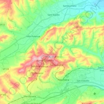
Nom : Carte topographique Macerata, altitude, relief.
Lieu : Macerata, Marche, Italy (43.25067 13.37814 43.36023 13.53466)
Altitude moyenne : 147 m
Altitude minimum : 48 m
Altitude maximum : 327 m
Typically hilly, the climate is both Mediterranean and continental. The Adriatic Sea, which is approximately 30 kilometres (19 mi) away, and particularly the Apennine Mountains influence the weather. The elevation of Macerata is approximately 315 metres (1,033 ft) above sea level, so winter is particularly rainy and the snow is not so frequent and plentiful. Balkanic and northwestern perturbations may cause snow. Middle seasons are variable, and late snowfall and frost may occur during April. October is neither warm nor very cold. Summer is rather sunny, and sometimes the thermometer reaches 40 °C (104 °F). Garbino is the cause, a hot wind from the hinterland. Summer thunderstorms are frequent in August during the evening, when the weather becomes quite unstable.