
Carte topographique Valencia
Carte interactive
Cliquez sur la carte pour afficher l’altitude.
Valencia
The city's topography is characterized as flat to undulating hills with extensive plateaus and mountainous areas and cliffs on both eastern and western portions bounding the municipality of San Fernando on the east and the municipality of Talakag on the west. Its highest point is Mount Kalatungan in the Kalatungan Mountain Range rising above 1,000 meters and above 50 percent slopes. These cover 25.72 percent of the total city area and major portions of Barangay of Lourdes, Guinoyuran and Lilingayon.
À propos de cette carte
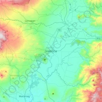
Nom : Carte topographique Valencia, altitude, relief.
Lieu : Valencia, Bukidnon, Northern Mindanao, 8709, Philippines (7.74288 124.92980 8.06288 125.24980)
Altitude moyenne : 566 m
Altitude minimum : 222 m
Altitude maximum : 1 690 m
Autres cartes topographiques
Cliquez sur une carte pour visualiser sa topographie, son altitude et son relief.
Lake Apo
Philippines > Bukidnon > Valencia
Lake Apo is a crater lake in Barangay Guinoyoran in the city of Valencia in Bukidnon province in the Philippines. It is located in a hilly area about 640 metres (2,100 ft) in elevation, about 11 kilometres (6.8 mi) WSW of the city poblacion (town center). Lake Apo was awarded the cleanest inland body of water…
Altitude moyenne : 643 m