
Carte topographique Eaton Rapids
Carte interactive
Cliquez sur la carte pour afficher l’altitude.
À propos de cette carte
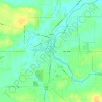
Nom : Carte topographique Eaton Rapids, altitude, relief.
Lieu : Eaton Rapids, Eaton County, Michigan, 48827, United States (42.48798 -84.67308 42.53092 -84.63060)
Altitude moyenne : 272 m
Altitude minimum : 261 m
Altitude maximum : 289 m
Autres cartes topographiques
Cliquez sur une carte pour visualiser sa topographie, son altitude et son relief.
Eaton Rapids Township
United States > Michigan > Eaton County
Eaton Rapids Township, Eaton County, Michigan, United States
Altitude moyenne : 274 m
Vermontville
United States > Michigan > Eaton County
Vermontville, Vermontville Township, Eaton County, Michigan, United States
Altitude moyenne : 272 m
Sunfield
United States > Michigan > Eaton County
Sunfield, Sunfield Township, Eaton County, Michigan, United States
Altitude moyenne : 262 m
Bellevue
United States > Michigan > Eaton County
Bellevue, Bellevue Township, Eaton County, Michigan, United States
Altitude moyenne : 267 m
Windsor Charter Township
United States > Michigan > Eaton County
Windsor Charter Township, Eaton County, Michigan, 48821, United States
Altitude moyenne : 271 m
Olivet
United States > Michigan > Eaton County
Olivet, Eaton County, Michigan, United States
Altitude moyenne : 275 m
Mulliken
United States > Michigan > Eaton County
Mulliken, Roxand Township, Eaton County, Michigan, United States
Altitude moyenne : 261 m
Dimondale
United States > Michigan > Eaton County > Windsor Charter Township
Dimondale, Windsor Charter Township, Eaton County, Michigan, United States
Altitude moyenne : 266 m
Oneida Charter Township
United States > Michigan > Eaton County
Oneida Charter Township, Eaton County, Michigan, 48837, United States
Altitude moyenne : 268 m
Vermontville Township
United States > Michigan > Eaton County
Vermontville Township, Eaton County, Michigan, 49096, United States
Altitude moyenne : 269 m
Grand Ledge
United States > Michigan > Eaton County
Grand Ledge, Eaton County, Michigan, United States
Altitude moyenne : 259 m
Waverly
United States > Michigan > Eaton County > Delta Charter Township
Waverly, Delta Charter Township, Lansing Charter Township, Eaton County, Michigan, 48917, United States
Altitude moyenne : 262 m
West Windsor
United States > Michigan > Eaton County
West Windsor, Windsor Charter Township, Eaton County, Michigan, 48821, United States
Altitude moyenne : 277 m
Potterville
United States > Michigan > Eaton County
Potterville, Eaton County, Michigan, 48876, United States
Altitude moyenne : 275 m
Delta Charter Township
United States > Michigan > Eaton County
Delta Charter Township, Eaton County, Michigan, 48917, United States
Altitude moyenne : 263 m
Charlotte
United States > Michigan > Eaton County
Charlotte, Eaton County, Michigan, United States
Altitude moyenne : 278 m
Delta Charter Township
United States > Michigan > Eaton County
Delta Charter Township, Eaton County, Michigan, 48917, United States
Altitude moyenne : 263 m
Grand Ledge
United States > Michigan > Eaton County > Grand Ledge > Grand Ledge
Grand Ledge, Eaton County, Michigan, 48837, United States
Altitude moyenne : 259 m