
Carte topographique Storthes Hall Park Campus
Carte interactive
Cliquez sur la carte pour afficher l’altitude.
À propos de cette carte
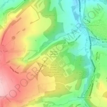
Nom : Carte topographique Storthes Hall Park Campus, altitude, relief.
Altitude moyenne : 173 m
Altitude minimum : 85 m
Altitude maximum : 275 m
Autres cartes topographiques
Cliquez sur une carte pour visualiser sa topographie, son altitude et son relief.
Thunderbridge
United Kingdom > England > Kirklees > Kirkburton
Thunderbridge, Kirkburton, Stocksmoor, Kirklees, West Yorkshire, England, HD8 0PX, United Kingdom
Altitude moyenne : 188 m