
Carte topographique Shiyan
Carte interactive
Cliquez sur la carte pour afficher l’altitude.
À propos de cette carte
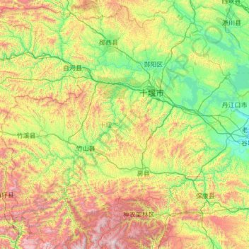
Nom : Carte topographique Shiyan, altitude, relief.
Lieu : Shiyan, Hubei, China (31.50762 109.43630 33.27277 111.57990)
Altitude moyenne : 782 m
Altitude minimum : 78 m
Altitude maximum : 2 898 m
The far northern and southern reaches of Shiyan are the highest in elevation, while the geographic center of the city has a relatively low elevation. The highest point in Shiyan is Congping in Zhuxi County, at 2,740.2 metres (8,990 ft) above sea level, while the lowest point, Panjiayan in Danjiangkou, is 87 metres (285 ft) above sea level. Hills and mountains in Shiyan generally have steep inclines, and many of its rivers have steep drops and rapid water flows. Major rivers in Shiyan include the Du River and the Han River. The Wudang Mountains run east-west through Shiyan. The peak commonly referred to as "Wudang Mountain", or in Mandarin Wudangshan, is one of the most important cultural centres of the Taoist faith. The surrounding areas are dotted with up to 200 Taoist monastic temples and religious sites.
Autres cartes topographiques
Cliquez sur une carte pour visualiser sa topographie, son altitude et son relief.