
Faire un don
Équipez-vous pour votre prochaine aventure :
En tant que Partenaire Amazon, ce site perçoit une commission sur les achats éligibles sans surcoût pour vous.
Carte topographique Scandinavian Mountains
Cliquez sur la carte pour afficher l’altitude.
Faire un don
Équipez-vous pour votre prochaine aventure :
En tant que Partenaire Amazon, ce site perçoit une commission sur les achats éligibles sans surcoût pour vous.
Scandinavian Mountains
The mountain chain's highest summits are mostly concentrated in an area of mean altitude of over 1,000 m (3,300 ft),) between Stavanger and Trondheim in South Norway, with numerous peaks over 1,300 m (4,300 ft) and some peaks over 2,000 m (6,600 ft). Around Trondheim Fjord, peaks decrease in altitude to about 400–500 m (1,300–1,600 ft), rising again to heights in excess of 1,900 m (6,200 ft) further north in Swedish Lapland and nearby areas of Norway. The southern part of the mountain range contains the highest mountain of Northern Europe, Galdhøpiggen at almost 2,500 m (8,200 ft). This part of the mountain chain is also broader and contains a series of plateaux and gently undulating surfaces that hosts scattered inselbergs. The plateaux and undulating surfaces of the southern Scandinavian Mountains form a series of stepped surfaces. Geomorphologist Karna Lidmar-Bergström and co-workers recognize five widespread stepped surfaces. In eastern Norway, some of the stepped surfaces merge into a single surface. Dovre and Jotunheimen are rises from the highest of the stepped surfaces. In south-western Norway, the plateaux and gently undulating surfaces are strongly dissected by fjords and valleys. The mountain chain is present in Sweden from northern Dalarna northwards; south of this point the Scandinavian Mountains lie completely within Norway. Most of the Scandinavian Mountains lack "alpine topography", and where present it does not relate to altitude. An example of this is the distribution of cirques in southern Norway that can be found both near sea level and at 2,000 m (6,600 ft). Most cirques are found between 1,000 and 1,500 m (3,300 and 4,900 ft).
Faire un don
Équipez-vous pour votre prochaine aventure :
En tant que Partenaire Amazon, ce site perçoit une commission sur les achats éligibles sans surcoût pour vous.
À propos de cette carte
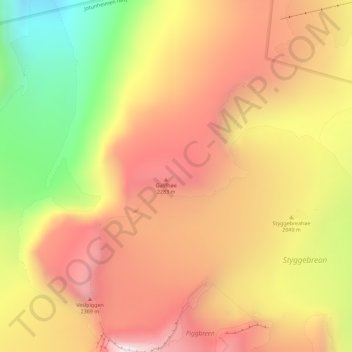
Nom : Carte topographique Scandinavian Mountains, altitude, relief.
Lieu : Scandinavian Mountains, Lom, Innlandet, Norway (61.64995 8.31995 61.65005 8.32005)
Altitude moyenne : 2 050 m
Altitude minimum : 1 484 m
Altitude maximum : 2 467 m
Faire un don
Équipez-vous pour votre prochaine aventure :
En tant que Partenaire Amazon, ce site perçoit une commission sur les achats éligibles sans surcoût pour vous.
Autres cartes topographiques
Cliquez sur une carte pour visualiser sa topographie, son altitude et son relief.
Dovre
The Dovre area is in a valley at fairly high altitude and isolated from the sea by mountain ranges, giving some rain shadow effect for Dovre. Dovre, with the town Dombås, has a subarctic climate (Dfc) with sparse precipitation. The driest season is late winter and spring, and the wettest season is summer.…
Altitude moyenne : 1 195 m
Faire un don
Équipez-vous pour votre prochaine aventure :
En tant que Partenaire Amazon, ce site perçoit une commission sur les achats éligibles sans surcoût pour vous.
Faire un don
Équipez-vous pour votre prochaine aventure :
En tant que Partenaire Amazon, ce site perçoit une commission sur les achats éligibles sans surcoût pour vous.
Faire un don
Équipez-vous pour votre prochaine aventure :
En tant que Partenaire Amazon, ce site perçoit une commission sur les achats éligibles sans surcoût pour vous.
Hamar
Hamar has a humid continental climate (Dfb) with fairly dry and cold winters, and comfortably warm summers. The Hamar II weather station, at an elevation of 141 metres (463 ft), started recording in 1968. The all-time high 33 °C (91 °F) was recorded in July 2018, which was the warmest month on record with…
Altitude moyenne : 445 m
Faire un don
Équipez-vous pour votre prochaine aventure :
En tant que Partenaire Amazon, ce site perçoit une commission sur les achats éligibles sans surcoût pour vous.
Faire un don
Équipez-vous pour votre prochaine aventure :
En tant que Partenaire Amazon, ce site perçoit une commission sur les achats éligibles sans surcoût pour vous.
Faire un don
Équipez-vous pour votre prochaine aventure :
En tant que Partenaire Amazon, ce site perçoit une commission sur les achats éligibles sans surcoût pour vous.
Faire un don
Équipez-vous pour votre prochaine aventure :
En tant que Partenaire Amazon, ce site perçoit une commission sur les achats éligibles sans surcoût pour vous.
Faire un don
Équipez-vous pour votre prochaine aventure :
En tant que Partenaire Amazon, ce site perçoit une commission sur les achats éligibles sans surcoût pour vous.