
Faire un don
Équipez-vous pour votre prochaine aventure :
En tant que Partenaire Amazon, ce site perçoit une commission sur les achats éligibles sans surcoût pour vous.
Carte topographique Cluj-Napoca
Cliquez sur la carte pour afficher l’altitude.
Faire un don
Équipez-vous pour votre prochaine aventure :
En tant que Partenaire Amazon, ce site perçoit une commission sur les achats éligibles sans surcoût pour vous.
Cluj-Napoca
A wide variety of flora grow in the Cluj-Napoca Botanical Garden; some animals have also found refuge there. The city has a number of other parks, of which the largest is the Central Park. This park was founded during the 19th century and includes an artificial lake with an island, as well as the largest casino in the city, Chios. Other notable parks in the city are the Iuliu Hațieganu Park of the Babeș-Bolyai University, which features some sport facilities, the Hașdeu Park, within the eponymous student housing district, the high-elevation Cetățuia, and the Opera Park, behind the building of the Cluj-Napoca Romanian Opera.
Faire un don
Équipez-vous pour votre prochaine aventure :
En tant que Partenaire Amazon, ce site perçoit une commission sur les achats éligibles sans surcoût pour vous.
À propos de cette carte
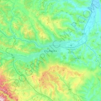
Nom : Carte topographique Cluj-Napoca, altitude, relief.
Lieu : Cluj-Napoca, Cluj, 400133, Romania (46.60938 23.42995 46.92938 23.74995)
Altitude moyenne : 490 m
Altitude minimum : 274 m
Altitude maximum : 1 207 m
Faire un don
Équipez-vous pour votre prochaine aventure :
En tant que Partenaire Amazon, ce site perçoit une commission sur les achats éligibles sans surcoût pour vous.