
Carte topographique Lake Tekapo
Carte interactive
Cliquez sur la carte pour afficher l’altitude.
À propos de cette carte
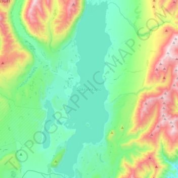
Nom : Carte topographique Lake Tekapo, altitude, relief.
Lieu : Lake Tekapo, Mackenzie District, Canterbury, New Zealand (-44.00704 170.46177 -43.77987 170.56512)
Altitude moyenne : 1 025 m
Altitude minimum : 623 m
Altitude maximum : 2 136 m
Lake Tekapo (Māori: Takapō) is the second-largest of three roughly parallel lakes running north–south along the northern edge of the Mackenzie Basin in the South Island of New Zealand (the others are Lake Pukaki and Lake Ōhau). It covers an area of 83 square kilometres (32 sq mi) and is at an altitude of 710 metres (2,330 ft) above sea level.
Autres cartes topographiques
Cliquez sur une carte pour visualiser sa topographie, son altitude et son relief.
Mount Lloyd
New Zealand > Canterbury > Mackenzie District
Mount Lloyd, Mackenzie District, Canterbury, New Zealand
Altitude moyenne : 1 610 m
Mount Nathan
New Zealand > Canterbury > Mackenzie District
Mount Nathan, Mackenzie District, Canterbury, New Zealand
Altitude moyenne : 2 344 m
Twizel
New Zealand > Canterbury > Mackenzie District
Twizel, Mackenzie District, Canterbury, 7901, New Zealand
Altitude moyenne : 472 m
Mount Cook
New Zealand > Canterbury > Mackenzie District
Mount Cook, Mackenzie District, Canterbury, New Zealand
Altitude moyenne : 2 920 m